|
CWCS to SWAP
This is the first of a six part series. The reader is highly encouraged to go to these websites and study what is discussed in these articles in order to make an informed decision. The Island Park area is targeted by an aggressive agenda that could potentially destroy what we have always known and loved. To fully understand this agenda it is important to understand its history. In 2001, the U. S. Congress appropriated federal funds to states for wildlife and fish conservation along with the responsibility to develop a comprehensive wildlife conservation strategy. These strategies were intended to lay the foundation for "a coordinated vision and mechanism to enact conservation at a landscape level". Because this statement was so benign it was difficult for local residents or elected officials to understand its true meaning. In 2005, the Idaho Department of Fish and Game (IDFG) finished the required Comprehensive Wildlife Conservation Strategy (CWCS). The intent was to pass on "our ecological heritage to future generations", and engage others towards this endeavor. The purpose of this strategy was to identify species of greatest conservation need (SGCN) and habitats for conservation, use legal instruments for conservation methods, and involve the public. "Ecosystem management" was also included. Seen as a "living document", open to ongoing revisions, the strategy also recognized "the need for increased and permanent federal conservation funding...". Participants in the CWCS included multiple government agencies and UN NGOs. The Wilderness Society (WS), The Nature Conservancy (TNC), Defenders of Wildlife, NatureServ (a partner of the UN program IUCN), and the Idaho Conservation League (ICL) which attaches itself to the Wilderness Society were all actively involved in the CWCS. Local Island Park working groups and elected representatives were not asked to participate as the strategy had intended. "Coordination" took place between federal and state government agencies, other states, land trusts, and even Canada with consultation on regional plans. But Idaho citizens were not included. Idaho was broken up into "eco sections", especially because of its "close association to TNC's ecoregional plans". This was just the beginning of blurring state, county, and private land jurisdictional boundaries. America's foundation is state sovereignty and local control through elected representation, which are are being erased. IDFG also declared, "All wildlife...within the state of Idaho, is hereby declared to be the property of the state of Idaho", to be "...preserved, protected, perpetuated, and managed.” The CWCS states it "does not require any person or entity to implement conservation actions", or "dictate how conservation actions should be implemented", but only to "provide information and general direction...in developing conservation plans" with the development of those conservation plans as "discretionary". In the strategy, species were inventoried, especially the SGCN, habitats for protection were prioritized, and a goal to prevent the spread of invasive species. Although IDFG declared itself as "...not a major land management agency..." it did include partnerships with land management agencies (land trusts groups), plans to "acquire interest in property", assisting private land owners in conservation practices, and reducing impacts from land development. The CWCS laid the foundation to gather data. This data was needed to later justify the creation of large conservation landscapes, and create wildlife and habitat corridors for connectivity. Partnering with UN NGOs, and with the CWCS, IDFG supported the Heart of the Rockies, Crown of the Continent, Greater Yellowstone, Yellowstone to Yukon, and the High Divide agendas, which all work to place land and species under conservation status, create corridors, and promote connectivity. Island Park narrowly escaped designation as a national monument. But conservation easements, corridors, and connectivity achieve the same result, loss of private land ownership and land use by Idahoans. In Idaho, the goal of these groups are connecting landscape from Yellowstone, across public and private land, over the Continental Divide, and into the Centennials. IDFG is putting policies into place that will help them achieve these goals. A Monitoring Oversight Team, which included the TNC, was formed to coordinate and monitor the implementation of the strategy. Its primary purpose was to develop an overall strategy, identify needs, and set priorities. The CWCS was seen as a "living document", open to any changes necessary. A review of the CWCS in 2010 included revision of the SGCN conservation status, identifying any actions needing modification, and strategy revisions. Recommended actions included encouraging conservation plans with farmers/ranchers, adjusting grazing schedules, reducing residential development, restricting OHV use, allowing naturally occurring fires to burn, identifying linkage zones that provide connectivity between habitats for wide-ranging species along roads and highways, locating and designing highways and roads to reduce and mitigate impacts to wildlife and key habitats, providing corridors of intact, minimally disturbed habitat for wide–ranging species, reducing development on lakes, and designing travel corridors. Establishing corridors for eventual connectivity were the true goals in the CWCS. At the 10 year revision of the the CWCS in 2015, with all that data gathered, we now have the State Wildlife Action Plan (SWAP). What was a strategy has now become the plan. SWAP will implement the creation of corridors beginning with the Hwy 20 Corridor plan, altering the IP landscape with artificial wildlife bridges and fences that wildlife will be forced to use in their migratory path. Elk were not identified in CWCS as a SGCN, but are now the species being used to justify the need for a corridor because of wildlife-vehicle-collisions (WVC). Highways and roads are the arteries that connect people to their land, the majority of which have been responsible in safely accommodating animals during migration across the roads. Attempts to environmentally engineer wildlife is very concerning. But the truth is, the creation of these corridors along highways and roads are stepping stones towards connectivity of large landscape areas. That was the real intent of the CWCS and now SWAP. As a neighbor to Yellowstone Park, Island Park has been, is, and will continue to be a targeted area for conservation by UN NGOs. They have a renewed and aggressive goal to convince private landowners to place their land into a conservation easements with partnering land trusts included in the CWCS. The agenda will not stop with wildlife. Part 2 will explain how biodiversity, ecosystems, and wetlands are used as justification to create corridors of connectivity.
0 Comments
Biodiversity & Ecosystems This is the second of a six part series. The reader is highly encouraged to go to these websites and study what is discussed in these articles in order to make an informed decision. After gathering wood in the forest for a warm fire, my father insisted that we not only clean up our mess, but clean up other slash and debris in the area. I did not understand at the time he was teaching us how to take care of the land in Island Park. Another dreaded chore was cutting down tall, overgrown grass around the cabin during the hot August summers. He knew this was a fire load that could potentially fuel a major fire. But we also went on our special trip for huckleberries. No habitat was destroyed, the vegetation is still there, and the huckleberries still grow. Daddy, thank you for teaching me how to care for and respect the land in Island Park. Coined in 1935, ecosystem is defined as "a system, or a group of interconnected elements, formed by the interaction of a community of organisms with their environment." Ecosystems have different components of growing, living species. One component is biodiversity. It is defined as "diversity among and within plant and animal species in an environment." Island Park has a multitude of different species which we all love such as wild strawberries, morels, watercress, trees, rainbows, brookies, skunks, porcupines, and the beloved moose and elk. From all indications, each continues to survive in Island Park. Wetlands are "land that has a wet and spongy soil, as a marsh, swamp, or bog." Island Park has the most beautiful marsh behind Elk Creek. In spite of weekly horseback riding through that marsh there was no long term damage. The marsh still exists. Riparian refers to the bank of a river or lake and anything living around it such as fish, other water species, and vegetation. Elk and other animal species use it for water and food. We use it to cast a fly for fish that might take a bite or jumping in for a swim, or maybe just look for a pretty rock. Wildlife, biodiversity, wetlands, and riparian areas are just a few ecosystem components. They are interconnected, dependent on each other for survival, and terms used by NGOs and government agencies to justify their work. Humans are one component not always mentioned. Not seen as a necessary presence in the ecosystem, humans are more often than not considered a destructive force, requiring removal for ecosystem protection. Conservation and removing all human activity are scientists and NGO goals. There is grave concern that land development is encroaching upon buffer zones, areas that surround a protected area which are intended to shield the core area from man’s activities, thus allowing more space for mammals. Private land ownership is in a precarious position. There are ongoing discussions about controlling land use planning from regional to municipal levels. Seen as part of "ecosystem management", land use planning objectives include conservation, stopping development, zoning and growth controls, and increasing restrictions. How you design your home and land will be dictated to you. This article by ScienceDirect explains it beautifully. Land, plant, and animal species don't understand boundaries, extending themselves across states, into designated parks such as West Yellowstone, and even across countries. Ecosystems are viewed in the same manner, there are no jurisdictional boundaries. NGOs such as The Nature Conservancy (TNC), believe these ecosystems, components and corridors, have the right to protection regardless of jurisdictional boundaries. These boundary erasures create a regional concept, erasing boundaries between states and counties, the United States and other countries, and create an artificial "conservation boundary". Essentially, the United States is being divided up into regions with artificial boundaries made up of different conservation areas. Here is a map of "conservation planning boundaries" from the Wildlands Network, which includes the current agenda in Island Park, Yellowstone to Yukon and Crown of the Continent. Part of the proposed US 20 IP Corridor Plan is the placement of artificial overpasses for safer passage during Elk migration, just a first step towards creating artificial corridors for connectivity. Each ecosystem component will be gradually introduced for protection, such as riparian areas. Riparian areas extend into surrounding wetlands and other water sources which will extend boundaries further for conservation. Ecosystem components will eventually be used to place the whole environment into some type of corridor needing protection, either through conservation or designation as a protected site. Remember, your private property will be impacted by this.
All of this falls under the Climate change umbrella. According to NGOs drastic action must be taken to not only conserve areas and protect them from humans, "mitigation" measures must be undertaken to prevent loss from development and climate change. The essence of mitigation is to avoid, minimize, and offset environmental impacts to lands and waters. In 2016 the US Fish and Wildlife Service released their new Mitigation Policy. This policy provides a framework and landscape-scale approach for mitigation with increasing conservation, no net loss of resources or values, and effective linkage for landscape scale conservation strategies. Created by the United Nations Environment Program (UNEP), the International Panel on Climate Change (IPCC) always uses science endorsing climate change. However, there is science that does not support the idea of climate change, or even if it exists. According to the International Climate Science Coalition (ICSC) there are opposing scientific views. Even the former Director of Greenpeace, Dr. Patrick Moore, now has doubts. As ecological engineers, scientists believe in giving "point value" to everything, a mathematical formula. Although the Island Park NGO conservation agenda has not yet advanced to creating corridors for other components, the same value points will be assigned to them. An example of this can be found in the Cramer Safety Solutions report used in the US 20 IP Corridor Plan, starting on page 159. For some reason land ownership and recreation receive low point value. The environment is remarkably skilled at regenerating itself. Our only job is using it and helping it when needed, like cleaning up the floor bed to reduce fuel loads. It is interesting that such a dichotomy exists with NGOs. On one hand their agenda is leaving the environment in its natural state. At the same time they are creating environmental engineering schemes to alter it. Use of this land, from the time my father was a teenager to present, did not cause any permanent damage requiring protection. Yet the future generation from that era, the current generation, is denied the right to use and enjoy this land as he did, with efforts underway to completely end all use. There is nothing that justifies this. The current wildlife passage project has nothing to do with Elk. This is a systematic agenda to alter where and how we live, and erase sovereign boundaries. It is part of a broader agenda to destroy state sovereignty and our foundation of government upon which America was built. My bond with Island Park grew from touching her land, hearing her sounds, seeing her beauty, tasting her gifts, and caring for her. Isolation from humans and landscape alteration are heartless and inhumane agendas, advanced by those who have no bond with her. To all those NGOs and scientists, we have been, and still are, the custodian, guardian, and protector of Island Park and her gifts, way before you were born or formed into little special interest groups, this was not invented by you, and we care for it more responsibly. There has been no long term damage to Island Park from those who have lived here for generations, there is nothing broke that needs fixed. The most comprehensive and destructive land polices were only born when NGOs became involved. Ask any rancher or farmer, they know. The true agenda is pushing us off our land into cities, taking control of our resources, and dictating how, if at all, we can use what is rightfully ours. Island Park is our heritage, our ancestry, we are a native and indigenous people, and we will defend her. There is no bond between you and Island Park such as mine. Part 3 will discuss corridors. Although this article is regarding Island Park, every Idahoan throughout the state will be affected by the same agenda. It must be time to transform Island Park into something else using "action plans". The question is, what needs to be transformed? What in Island Park needs fixing? The Idaho Department of Fish and Game (IDFG) has been working tirelessly for 10 years, inspecting Island Park with partnering "experts", creating a list of "problems" they deem necessary to fix, and then creating a plan to fix those problems "they" identified! This endeavor was for the revision of the State Wildlife Action Plan, or SWAP. These "experts" have identified conservation targets and the "threats" to those targets. The plan focuses on conserving fish and wildlife while helping humans "benefit" those species that need the most "help". This help by humans will be "voluntary" but the true goal is preventing all human activity that might endanger wildlife, and taking private land. Isn't it amazing that in spite of all federal and state agency work, and human activity, these species have managed to survive without these newly suggested efforts to help them, while at the same time managing to cohabitate with humans in healthy enough numbers to be studied in spite of the threats being identified? The Island Park area is now considered to be part of the Yellowstone Highlands, defined as an ecological subregion by the US Forest Service (USFS), because it comprises the western margins of the Yellowstone Plateau. This is most likely a deliberate choice as one eventual goal is to incorporate the Island Park area into the Yellowstone system, whether in the park itself or the protected lands within the "ecosystem". Currently, this is being accomplished through incremental demand that wildlife should have access to habitat outside of the park perimeter, such as the Natural Resources Defense Council (NRDC) wanted with the buffalo, and the Nature Conservancy. It will only be a matter of time before the demand is made that all wildlife have the right to access habitat across boundaries, with Island Park being a target for incorporation into Yellowstone. By the way, the NRDC and Nature Conservancy are both United Nations (UN) non-governmental organizations (NGO). Here is a map of all the "ecological sections" in the state so you can check yours out but the Section names might be unfamiliar to you. You will also notice that these Sections cross county lines, which is deliberate. 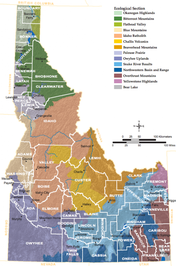 Now without having to wade through this whole document, here is the Section on the Yellowstone Highlands. But if you do have the time, here is the 1,458 page document that explains everything. Island Park sits right smack dab in a caldera created years ago from volcano activity, making it an ecologically significant area. But to the people who have lived there, and still do, the beauty of the area is really in their hearts, it is their HOME, not some Latin specimen. The Section begins by detailing the geographical and ecological aspects of the area, reducing it into nothing more than a dry statistical and scientific read that at times might be hardly understandable to the casual reader. Within these pages humans are identified as the terrible souls who are responsible, and at fault, for destroying habitat and wildlife. The Section notes that housing has "tripled" since 1963 with an "...estimated 150 square miles of currently undeveloped private land...", predicting that it will be altered with more housing in the next 10 years, while insinuating that the destruction is the result of private land use. To disrupt or prevent this habitat destruction, the plan targets 5 habitat conservation areas (forest, Aspen, riparian forest, wetlands, Henry's Lake Flat), and for good measure 2 wildlife species, the ungulate and grizzly which face "special conservation needs". These targeted conservation areas include private land. The plan identifies Species of Greatest Conservation Need (SGCN), ranging from bees, owls, toads, bats, loons, grouse, wolverines, cranes, swans, down to the tiny duskysnail. These species have associated conservation targets, meaning land. And realistically, there is at least one of these critters on each piece of private land. Just one warning side note, for the "regionally rare" ungulate, the target is to "...capture the process of ungulate seasonal migration and resource use through the area as well as more localized species movement. Includes seasonal, transitional, and stopover habitat." (You know, the ones that stop for a cup of joe on their journey, or may find the habitat favorable and decide to stay awhile). "US Hwy 20 presents a threat to connectivity... (and) potential expansions...would decrease permeability. Rural residential development also poses current and future threats to key transitional habitat in Shotgun Valley, Henry's Lake Flat, and the south rim of the caldera." For those who live in those areas watch out, IDFG or an NGO will be knocking on your door to tie up your land for a "regionally rare" animal. Through mapping, the plan identifies the Lodge Pole pine as the dominant tree with a sprinkling of Douglas Fir. For locals and just by observation one has to wonder how much it cost to figure that out. But since these trees are homes to the critters, the experts decided the trees provide "low value for sustaining biodiversity", meaning a poor quality habitat. Interesting. Just how did those critters survive so long in this inadequate housing? They go on to mention some of the bushes in the area like sagebrush, chokecherry, and yum, huckleberry. The experts also decided these conifers were encroaching upon the Aspen population. Maybe if the USFS would allow proper thinning this wouldn't happen. Now what could be worse than Douglas-fir habitats being "threatened by fire exclusion and rural residential development, while mature coniferous forests are most threatened by habitat fragmentation from roads.", citing that " low–intensity fires maintain a naturally diverse stand composition and structure that benefits a wide range of wildlife...". Prescribed burns have been used for generations by Tribes and ranchers and these experts are just now getting a clue? The USFS was the federal agency that reduced prescribed burning so now a law is needed to allow it again. Where is the logic in any of this? By their own admission "Fire suppression has also greatly reduced the presence of aspen...". So the federal government, once again, has created a catastrophe that has to be fixed with another law. According to the plan, "Roads can have negative impacts on fish, amphibians, reptiles, birds, and mammals...", and "...many roads have been gated under the assumption that limited use by “administrative traffic” will not unduly disturb elk and other wildlife. Unfortunately, this assumption is untrue, and even a limited amount of administrative traffic behind closed gates provides more than adequate reinforcement of the avoidance behavior”. That is the IDFG talking, a truck rolling through every month causes animals to avoid the area. Previous closures and restricted access has now become no human access or use. Alleged damage from ATVs, motorcycles, or snowmobiles can be read about in the Section, but most Idahoans know that seasonal changes remove any evidence of casual use, not long term damage, and the habitat is still there. According to the IDFG, agriculture, livestock grazing, housing development, recreation, and timber harvest are all land uses causing negative impact in the Yellowstone Highlands. To read about all the alleged damage you can go to page 492 in the Section. Also, these "...land uses have fragmented riparian habitat, reducing connectivity necessary for species movements." Once again connectivity is mentioned, it is the theme for all future landscape planning. But it is connectivity for wildlife and habitat, not humans or private property. Just know, the IDFG states, "This region is a national conservation priority landscape...". The true goal is locking up all the land in that area by increasing restricted use, including private property. Also, "...lower elevation lands in the GYE have some of the most productive habitats, but also face many looming threats, particularly on private lands." The plan also highlights the conservation importance of the Yellowstone Highlands "for maintaining the ecological integrity of the GYE (Greater Yellowstone Ecosystem)." This is right where Island Park lies and why banning human activity is so important. This is the same goal for the rest of the state. For any private land owner who is contemplating a conservation easement (CE), read this document first. It should also be read by those who have already placed their land in easements. Idaho Statute 55, Chapter 21 covers the law regarding CE, while 55-2102(3) states, "...a conservation easement is unlimited in duration unless the instrument creating it otherwise provides." 55-2103 covers CE court actions. CE are nothing more than a tool used by the federal government to shift private land into public land classification. Conservation easements rob the county of revenue, can be resold to the government for a higher price, and can increase property taxes for others. Placing private land into public hands is one major reason CE and land trusts are heavily promoted in the SWAP plan. Protect your rights by understanding the laws, don't believe what NGOs tell you. The document below gives just a brief summary of corrective action plans to reduce all of these "threats". All actions can be found in the Section link boxes.
The people who worked on this report included multiple state and federal agencies, UN NGOs, Tribes, and Land Trusts. Were the citizens who live in Island Park thoroughly notified and allowed to have input into what is being done to them? Oh, pardon, there was a paltry 45 that provided public input, along with an organized number from participating NGOs, 3 webinars, and one meeting in Boise. At what point will "voluntary" participation become mandatory? For all their hard work, the IDFG will be rewarded by the federal government with more money for their extremism. But what is the true source of this larger landscape transformation?
As a partner to the International Union for Conservation of Nature (IUCN), a UN participant, the US Fish and Wildlife Service implements IUCN objectives, one of which is addressing "threats' to wildlife, habitats, wetlands, etc., and advocating for special land protections. IUCN categorizes different protected areas. Category IV is Habitat/Species Management Area and best applies to what IDFG has done in their new plan. Since the Yellowstone Highlands is considered part of the GYE, the IUCN Category II also applies, which focuses on maintaining a whole ecosystem. Here is a shorter version of Category II. It all lines up with the IDFG plan. The United Nations Forum on Forests (UNFF), another UN outfit, has made another aggressive push for this agenda in their "Global Forest Goals" this year, specifically Goals 2.5, 3.1, 6.2, and 6.3. The UN Food and Agriculture Organization (FAO), has the same priorities. Here are a couple of other interesting articles on this from CFACT and the Wyoming Daily Independent. Many of these IDFG "experts" may not appreciate the disclosure and exposure of the truth in this article. There is growing awareness of this agenda along with growing outrage by Idaho citizens. The outrage is knowing a state agency willingly follows UN dictates, partners with UN NGOs to advance UN ideology, implements UN practices over and over which are destructive to our land, while at the same time, advancing UN ideology that the destruction is due to climate change. Idaho citizens are also outraged that the state, and federal government, are using aggressive and covert tactics towards private land and its use, using legal instruments and foot soldiers to take land from Idahoans for their possession, while banning traditional practices and uses through their agencies. To advance this agenda, federal agencies are promoting a growing, forceful regulatory stance with blurring of jurisdictional boundaries. Idahoans are no fools, they know the land better than any UN or IDFG partnered "expert". Idahoans have been forced to sit by and watch the destruction of our land, private property, liberties, and theft of their land through deception. Rather than working with its own citizens to solve concerns, IDFG chooses the UN and its partners. It cannot be denied that the federal government partners with the UN to advance and implement its policies which has subsequently trickled down to affect every Idahoan. Need more evidence? In the top right hand column of page 45157 in this 1998 federal register it clearly states the federal government is implementing Agenda 21, and this was just the beginning. It is more insidious now as the term used is "sustainable development". Sustainable development is Agenda 21. The IDFG plan is outlined in Agenda 21, Chapter 15, and now in Agenda 2030 Goal 15. It is not a conspiracy, it is fact. Idahoans, not just those in Island Park and Fremont county (forget that other name), are encouraged to look at the plan and how it will affect their area under the SWAP Ecological Sections here. The use of endangered species, including ecosystem and habitat protection, are the means to the end in achieving the goal of putting more land into the federal government hands and force Idahoans out. Don't fall for it! Fight back and say NO when they come to your door. Tell all of them, NGOs and government officials, their hidden agenda is known to you. Know the law. Ask them, where is the law, whether state or federal, that gives them the authority to do this? They will stumble because there is no federal or state law. Do everything you can to make them understand their agenda is not welcome, will not be tolerated, or accepted in your community. Educate them on the truth, and keep educating them until they understand, all the while not complying with their plans. Do whatever you can to never have to say, So Long, Island Park. The federal government created a beast, landscape conservation cooperatives (LLC) for wildlife protection, sprouting in 2011 following the "America Great Outdoors" initiative in 2010. No congressional approval came with this, the Department of Interior (DOI) just created it and assigned the U.S. Fish & Wildlife Service (FWS) to implement it. The FWS claims it is "...self-directed partnerships between federal agencies, states, tribes, non-governmental organizations, universities, and other entities...". Yeah, right. In the article, Kiss Idaho Goodbye, the discussion centered around only the Great Northern Landscape Conservation Cooperative (GNLCC). But that is only part of the story. Here is the rest of the map. 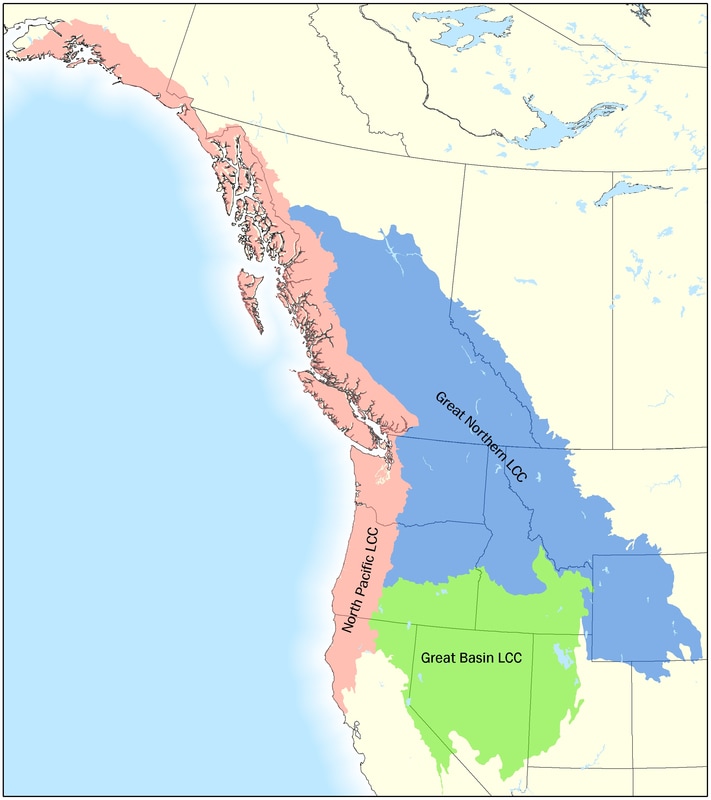 The rest of Idaho will be taken by the Great Basin LCC (GBLCC). Here is the GBLCC Strategic Plan for your southern Idaho area.
Like all of the other 21 LLCs in the United States, GBLCC networks with other LLCs through the Landscape Conservation Cooperative Network (LCCN). This network is pretty boastful about crossing all boundaries in its work, across state and county lines, and with other countries, in fact sucking up every piece of dirt in the United States. One of their goals is habitat connectivity which includes helping what they think are ignorant animals figure out how to migrate without getting hit by a vehicle, thus requiring their own personal passage. Of course, the LCCN includes the United Nations (UN) International Union for Conservation of Nature (IUCN) as a close partner. What the IUCN promotes, the network delivers to all of their little conspirators. Another group, the Network for Landscape Conservation, works with the IUCN and National Park Service (NPS), but looks suspiciously like an NPS program similar to FWS. One section not discussed in the first article was the Salmon Selway which is part of the Trust for Public Land (TPL). TPL partners with corporations, such as the World Business Council for Sustainable Development (WBCSD), a UN organization, and Disney, a UN partner. One of its jobs is to protect public lands from going into your hands, let alone allowing you to use them in your area. The other activity they engage in is purchasing land for conservation easements which ultimately tightens the connectivity and puts more land into government hands. Here is an example of their other dirty work in Georgia, buying private property and putting it into the hands of the National Park Service. Incidentally, TPL was founded by a former director of the Nature Conservancy. Being part of the TPL, the Salmon Selway has been used to "...conserve the most critical private lands...", that is, putting that land into government hands. The map in the link will show you the areas they have stolen from Idahoans. So the federal government created a system where they could hide themselves behind their partnership with UN affiliated buddies to do their dirty work up front, and create scams to steal more land from Idahoans. What exactly are they doing? Well, we have to keep going back to the IUCN as the federal government partners with them along with these other treasonous little groups, whether directly or indirectly. As an IUCN partner the FWS supports funding and implementing ICUN programs, many of which are conservation programs such as conservation connectivity. In this IUCN document, they call these Areas of Conservation Connectivity (ACC), which "...interconnect protected areas and in doing so, they help integrate these areas into wider...landscapes..." (pg 25), which is exactly what the LCCs are doing. Thank goodness it will allow movement of individuals, actual humans, among habitat patches within home ranges (pg 31). The primary objective is to "...conserve and actively manage migratory route connectivity and the underpinning natural habitats..."(pg 32). The LCCs implemented by FWS initiatives are playing "...an increasingly important role in biodiversity conservation and in helping to achieve Target 11 of the CBD Strategy 2011-2020 (pg 40), another UN agenda. The IUCN also believes these areas should be "transboundary" (pg 27), and have had their eyeballs on West Yellowstone with their global conservation movement. Sorry IUCN, Yellowstone does not belong to you. You may have the arrogance to call it a Heritage site, but it is an American site, and as such, belongs to Americans. In spite of the IUCN claim that there should be "community involvement", the truth is this agenda is primarily driven by the federal government with its UN affiliated groups and foundations. Small communities like Island Park are being terrorized by all of them, the very people who live there, have roots there, and who care most about and understand the area. But with the new Agenda 2030 Goal 15, much progress is being made to take land away from us, put it into the hands of the UN and federal government, and continue the march towards the dismantling of America. And these groups call themselves Americans. Being an American while engaging in these activities is a dichotomy for which each of them should search their souls and beg for absolution. As seen from the full picture, Kiss Idaho Goodbye. Great Northern Landscape Conservation Cooperative (GNLCC) As noted in the previous post America's destruction continues to survive as long as programs are still being implemented that destroy us. For Idaho, not only is there the Columbia River Treaty re-negotiations that will take control of all water resources, there is also another major land take over. There are a multitude of Idaho non-profits and United Nations (UN) non-governmental organizations (NGO) that are aggressively pursuing connectivity projects. Essentially the goal is to connect large swaths of land in Idaho's east corner which neighbors Montana and Wyoming. They would love to see this land all locked up into one major landscape of wilderness, for wildlife only. The High Divide (HD), Crown of the Continent (COC), Yellowstone to Yukon (Y2Y), Greater Yellowstone (GY), and the land trust partnership group Heart of the Rockies Initiative (HOR), are just a few of the organizations that are destructively working to create wildlife corridors in the Island Park area. Each of these organizations are connected to UN NGOs such as the Nature Conservancy (NC), Wilderness Society (WS), and Wildlife Conservation Society (WCS). Don't be fooled by the new UN addition in red, a disclaimer that unless the organization is in consultative status it does not connote affiliation with the UN. That is flat out not true. And like children playing in a sandbox these groups all play with each other, are interconnected, and overwhelm us with their agenda. Here is the map that shows how much land they are after with the Salmon Selway not even included in this discussion. This map is proudly displayed on the WCS website, a trophy of the successful tromping of Idaho. 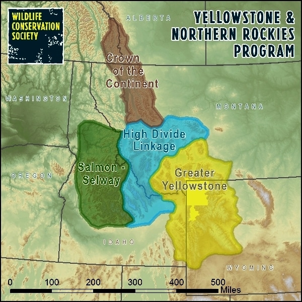 Quite a bit of money contributes to this takeover. Just the Greater Yellowstone alone has over 10 million dollars in their coffers. Where do they get all that money? Part of it is your tax dollar. Now your tax dollar goes to this in other ways as well. The Federal Highway Administration (FHA) believes in creating wildlife corridors which eventually contribute to connectivity and have spent your money to study it and figure out how many wildlife are affected by collisions. Forget how it has impacted humans. You are even paying your governor to participate in this through the Western Governors' Association (WGA). But don't forget the Idaho Transportation Department (ITD), your state taxes are used for this nonsense as well. Four years ago Idaho Fish & Game honored an ITD Senior Environmental Planner for his success in collectively garnering over 718,000 dollars to study (affectionately known as the Cramer study) where wolverines and bears migrate, and a study to prioritize wildlife collision areas. Here is the 2016 report and on page 6 you can see all the recommended overpasses, underpasses, fencing, traffic calming, and driver warning systems for Highway 20 in Island Park. What is truly remarkable about this is while our Idaho roads and bridges crumble there is plenty of money to spend on figuring out where cars collide with wildlife and put money into building a road for them. And here is the Highway 20 priority map for those animals. Now it makes sense why Idaho registration fees went up and why the current legislature has a huge task in front of them to fund transportation. Those bunnies need a safe passageway. Now there are many working tirelessly on this so surely it must all be coordinated together. Who else but the Great Northern Landscape Conservation Cooperative (GNLCC) to the rescue for connectivity. Established by the Department of Interior (DOI), it is an "international" network to advance collaborative landscape conservation. Here is the amount of land the GNLCC wants to take and a link to the data they have been collecting. Remember, this is the federal government doing it, not some obscure group. There are a multitude of participants, including multiple UN affiliates, making decisions about Idaho. 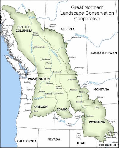 In a nutshell, the DOI created an organization that promotes these UN affiliated lunatics taking more land away from Idahoans. Originating in 2009 with order 3289, and advancing it with order 3330, then announcing the truth to "develop opportunities to further establish partnerships that benefit Tribes and Federal agencies" in order 3342.
The National Park Service (NPS) and US Fish & Wildlife Service (FWS) were granted the privilege of administering the GNLCC in 2010. The implementation plan includes partnerships with land protection NGOs and land trusts, Canada, IUCN, USFS, and the BLM while using the Endangered Species Act to justify its means. Of course they are using your tax dollar to stick it to you, not only in this way but in grants as well, up to one million. But the truth is, it is just the UN agenda. As a partner to the DOI, the International Union for the Conservation of Nature (IUCN) has been promoting connectivity for a very long time. As well, the FWS has its own comradery with the UN for migratory species protection. According to Agenda 2030, Goal 15.5, we are assigned the task to "Take urgent and significant action to reduce the degradation of natural habitats...". Roadkill should certainly be a focus to ensure a natural habitat is protected in a way that it does not cause harm to the animal. As this Agenda 2030 document explains in #33, "We are therefore determined to conserve and...protect biodiversity, ecosystems and wildlife." Look forward to paying for animal roads. The federal and state governments, as usual, are taking our money and using it against us, turning it over to UN groups for them to implement UN objectives. Can President Trump undo all of this? Or will it take the masses to finally stand up and say no more. How can the tiny community of Island Park fight this off? What are our legislators doing to stop this? Idahoans just continue to see our state being eaten up by government with its UN partnerships. Kiss Idaho Goodbye. |
Concerned Idahoans:This website is non-partisan and is solely dedicated to removing the harmful controls placed on our state and nation through associated programs of Agenda 21, Agenda 2030, and the Great Reset. We invite all Idahoans to join us in this fight for freedom! Categories
All
Archives
March 2024
|
||
 RSS Feed

