|
Conclusion
This is the last of a six part series. The reader is strongly urged to visit these websites and study what is discussed in these articles in order to make an informed decision. Part one covered data collection in the Comprehensive Wildlife Conservation Strategy (CWCS) which was used to create the State Wildlife Action Plan (SWAP) for species and habitat protection. In part two ecosystems and its components were covered and corridors were explained in part three. Part four exposed those who are involved in the effort to redesign Island Park. How Island Park residents are being excluded as a primary voice in decisions was exposed in part five. Now that the full truth is out, where does Island Park go from here? So now the truth is out. There are substantial organizations and foundations that work with federal agencies to promote connecting large landscapes into conservation with eventual regulatory requirements that will dictate how the Island Park community will be designed and how a property owners will be required to design their own land, or even use it. This is a covert agenda by outside groups, NGOs, and both state and federal governments to alter Island Park into some man made design, making it look like a zoo where wildlife can be "enjoyed" rather than letting her exist naturally as she has for generations. The starting point is wildlife vehicle collisions (WVC), the Elk who cross US 20 two times a year on their migratory path. Although Targhee Pass is identified as a primary area of crossing and need for an overpass, the Elk actually make their crossing a few miles south of Bighorn Hills. This would require fencing which would force the Elk to alter their natural path. No Elk, or any other wildlife, should die on their journey. The WVC numbers vary depending on which source is cited. All studies were conducted for the specific outcome of overpasses and connectivity while downplaying other alternatives, or even consideration for other possible options. Has the number of WVC, or even the number of Elk deaths increased in 50 years? Those numbers are never mentioned. These initiatives, NGOs, and government agencies with a massive agenda have decided to make the Elk an issue, with their bias, to implement their predetermined solutions. Those who are part of this agenda, these initiatives, will try to dissuade us from accepting the truth, controlling and manipulating the dialogue on compassion for wildlife and the "threat of human-wildlife conflict", while continuing to hide what is coming next and who is involved. That "conflict" is a fabrication from their fantasies. The perception that there is no compassion for the Elk will be promoted. They will try to marginalize folks who do not support their agenda and who are willing to listen to the truth. A negative impression of those who oppose the initiative will be painted as uncaring and disrespectful towards the beautiful animals we all care about. None of this is true. This type of rhetoric is only to distract from the truth, while defining you as the enemy. The larger discussion about private property restrictions and impacts, fencing, acquisition, multiple use reductions, other wildlife and endangered species, the bison and brucellosis, and the connectivity agenda have all been avoided and hidden, and will continue to be avoided if allowed by Island Park guardians. Elk are loved just as much by those who seek the truth. Perhaps their love for the Elk is greater for not wanting to change their natural habitat, forcing them into a man made environment. There is no reason to be ashamed for wanting to protect them and Island Park. Our Founding Fathers believed property rights exemplified the foundation of liberty. “Property is surely a right of mankind as real as liberty.” John Adams “No power on earth has a right to take our property from us without our consent.” John Jay (First Chief Justice) “Among the natural rights of the colonists are these: First a right to life, secondly to liberty, and thirdly to property; together with the right to defend them in the best manner they can.” Samuel Adams And others believed this as well. “The Right of property is the guardian of every other Right, and to deprive the people of this, is in fact to deprive them of their Liberty.” Arthur Lee “Ultimately property rights and personal rights are the same thing.” Calvin Coolidge Property rights are the most precious gift of our Republic. We are not a democracy where the mob rules, we are a Republic and a nation whose foundation is based on laws, laws that protect our rights. Because we are not a democracy, and in spite of what they may believe, the masses of individuals, groups, government agencies, and wealth behind this agenda do not rule. Fabricated changes to boundaries and rules about land by those with ideological beliefs must never be accepted. It seems most conflicts in the world are centered around the theft of property, the taking of land from others, often leading to battle. The theft occurring now is different in that there is no battle, but the war is the same. Island Park is sovereign, independent from Yellowstone Park, with clear jurisdictional boundaries, not only at a city and county level, but at the state level. These boundaries must be protected and defended. Island Park citizens must come together. They must become knowledgeable about NGOs, federal and state laws, and understand their rights. Understanding the hidden agenda is critical to understanding what rights will be taken from them. Citizens must ask questions, demand answers, and stand up for their rights, both as an Island Park resident and private property owner. Others must be educated on the issues and brought on board with regular meetings that keep everyone current on the issues. When not in residency everyone should stay connected through all means of social media, emails, and other methods, sharing information as it becomes available. Move the discussion beyond compassion for the Elk to the real issues being hidden. Coalition groups or advisory committees should be created to insist that your voice is the primary voice that must be heard with NGOs and other initiatives taking a back seat. Let them know their agenda is not welcome. A broader discussion in solving WVC is needed with other solutions brought forth, including alternatives that haven't been given any consideration. And there are others. If the technocrats say an alternative is not beneficial, research it, find out what other areas have tried them, and the results. Come up with new ideas and solutions and present them to ITD. Keep the pressure on them to listen. Land alteration and forcing a change in the migration path of Elk are not the only answers to protect them. As the guardians of Island Park, to those who are most bonded and connected to the land, stand up for her right to exist naturally, and your rights. Become involved and never allow anyone to change it into an artificially designed, faux zoo landscape. Appreciation for Island Park comes from how it has always existed.
0 Comments
Agendas This is the fifth of a six part series. The reader is highly encouraged to go to these websites and study what is discussed in these articles in order to make an informed decision. It is critical to understand the massive number of organizations who are involved in this connectivity agenda and who align with government agencies to advance it. In 2010, the Obama administration issued a memorandum, creating the America's Great Outdoors Initiative without any federal legislation, and assigning eight federal agencies to implement it. Two objectives were the creation of "corridors and connectivity", and advancing those "priorities through public private partnerships". A DOI order created 22 large landscape cooperatives across the U.S. with Island Park sitting in the Great Northern Large Landscape Cooperative (GNLCC). These cooperatives were tasked with coordinating all landscape conservation groups, including partnering federal agencies, placing land into conservation, and connecting them into large landscapes. There are 56 landscape initiatives that belong to the GNLCC including Yellowstone to Yukon (Y2Y), High Divide (HD), Crown of the Continent (COC), Heart of the Rockies (HOR), Greater Yellowstone Coalition Committee (GYCC), Western Governors Association (WGA), and multiple land trusts. Here is their Steering Committee. 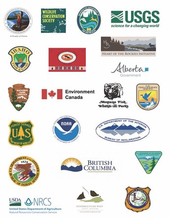 But there are other large landscape conservation groups as well. Gary Tabor is the founder of the Center for Large Landscape Conservation (CLLN), co-founded the Y2Y Conservation Initiative, the Roundtable of the COC, and co-designed the Western Governors’ Association Wildlife Corridors Initiative. The Conservation Corridor, an International Union for Conservation of Nature (IUCN) program, facilitates wildlife corridor and ecological connectivity conservation, of which Mr. Tabor is the regional leader Vice Chair. As recent as 2016, Mr. Tabor was participating with the IUCN for Areas of Connectivity Conservation. Here is the CLLN network of partners. 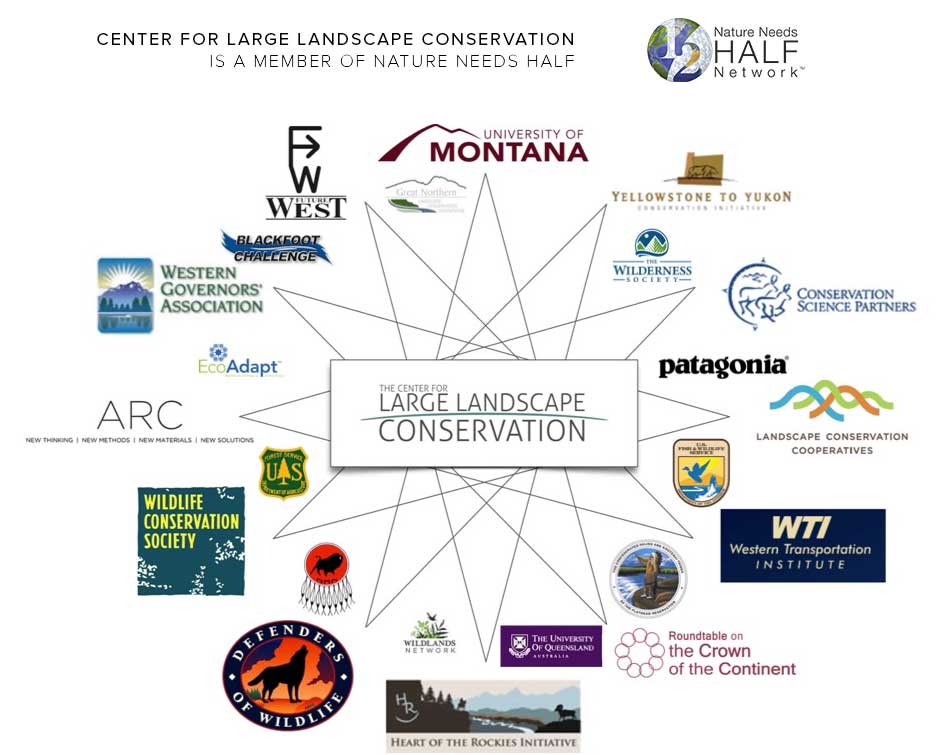 The Landscape Conservation Cooperative Network (LCCN), "is the collective of the 22 LCCs collectively", whose council consists of the BLM, USFS, NPS, USFWS, among others; NGOs NatureServe and TNC; four international participants; and the CLLC.
The Network for Landscape Conservation (NLC), was created by the University of Montana and Lincoln Institute for Land Policy (LILP). Their mission is "helping people work effectively across boundaries to...protect...or connect natural systems at the large landscape scale...", and support an "enduring system of protected and connected natural systems at the large landscape scale." Gary Tabor and Michael Whitfield are on the coordinating committee. The LILP has a Large Landscape Conservation Strategic Framework for Policy and Action. The WGA plans to launch a pilot project for wildlife mapping, identifying areas where development can occur with minimal impacts to wildlife, with Island Park being one project areas. Phase 1 includes inventorying species, habitat, unfragmented landscapes, protected habitats, and geographic features while evaluating connectivity tools and models in cooperation with NatureServe and WCS ongoing efforts to formulate connectivity best management practices. The project promises to contact all relevant stakeholders within the pilot area at the initiation of the project, including but not be limited to: Y2Y, WCS, and TNC. The project intends to hold at least 2 "stakeholder" meetings, with Island Park being one of those communities. By the end of Phase 1 they plan on having a "Completed connectivity/linkage plan identifying steps, tools, and outcomes for producing a connectivity data layer for the entire ID‐MT divide project area." The NGOs and HD must be thrilled. No start date was listed. The Brainerd Foundation funds the NGOs Earthjustice, TNC, SC, WS, and NWF; COC, GYC, Y2Y, FW, and HOR initiatives; the Henry's Fork Foundation and Sonoran Institute. The Sonoran Institute partners with the TNC, WS, BLM, USFWS, NPS, and the Bureau of Reclamation. The Wilburforce Foundation (WCS partner) funds Y2Y, and the Turner foundation also funds these agendas. As one can see, there are a substantial number of groups involved in this connectivity agenda, as well as money pouring in from wealthy individuals with the same ideology, and your tax dollar. But where are the voices whose heritage is bonded and connected to Island Park? Their voice, with first rights in importance, has been left out. The US 20 Corridor has a website specific to the Targhee Pass Environmental Assessment (EA) phase of the project. It states ITD, following National Environmental Policy Act (NEPA) requirements, is initiating an EA to evaluate risks, benefits, opportunities and costs associated with reconstruction of Targhee Pass, with the Federal Highway Administration (FHWA) as the lead agency. ITD has been studying the US 20 transportation corridor for 13 years, working with IDFG and the Henry's Fork Legacy Project (HFLP), assessing its condition, and identifying necessary improvements. Three studies were conducted during that time. 2014 (Cramer) - Methodology for Prioritizing Appropriate Mitigation Actions to Reduce Wildlife-Vehicle Collisions on Idaho Highways; 2014 (Seidler) - US 20 Island Park Wildlife Collision Study - an examination of Road Ecology in the Island Park Caldera: Elk and Moose migration across US Highway 20 - Final Report; and 2016 (Cramer) - Safety Solutions for Wildlife Vehicle Collisions on Idaho’s US 20 and SH 87. Technocrats and individuals from outside the area have the lead voice here. According to the website it was also during this time "one-on-one conversations with local agencies, municipalities, tribes and other key stakeholders" also took place, which were used for the Targhee Pass Environmental Study. ITD states comments on wildlife vehicle collisions (WVC) were "received in the scoping phase" of the study. Aside from the IDFG, HFLP, and technocrats, who? What Tribes? The website states the NEPA process begins when a federal agency develops a proposal to take a major federal action or (as in this case) when federal funds would be utilized to implement a project. Federal funds were approved for this project in October, 2016. So the NEPA process was started prior to the funding? What does federal law say? § 23 CFR 771.119 Environmental Assessments, § 771.111 Early coordination, Public involvement, and Project Development, and § 450.210 Interested parties, Public involvement, and Consultation, all require public involvement for transportation planning and actions requiring an EA. This is accomplished through an early coordination process and is incorporated into the EA which should be available for public inspection. One or more public hearings...at a convenient time and place for any...project which requires significant amounts of right-of-way, substantially changes the layout or functions of connecting roadways...or has a substantial adverse impact on abutting property are also part of the law. The state is also required to develop and use a documented public involvement process that provides opportunities for public review and comment at key decision points. What opportunity for involvement were citizens granted during the studies, or even from the beginning 13 years ago? § 23 USC 128: Public Hearings states, "Any State transportation department which submits plans for a Federal-aid highway project involving the by passing of or, going through any city, town, or village, either incorporated or unincorporated, shall certify to the Secretary that it has had public hearings, or has afforded the opportunity for such hearings, and has considered the economic and social effects of such a location, its impact on the environment, and its consistency with the goals and objectives of such urban planning as has been promulgated by the community." The ITD excluded all of this. Were public hearings held regarding proposed actions on the corridor, during a time when all were in residency? The website claims "The first step in the environmental assessment process is called scoping. This is an opportunity for the community to help identify issues and concerns specific to the study corridor." According to their timeline a study initiation and stakeholder assessment occurred in October, 2016. One public meeting was held in December with comments incorporated to refine alternatives and impact assessment methods in January, 2017. The subsequent April meeting was cancelled. The ITD Corridor Planning Guidebook mandates public participation and county official involvement at the beginning of any proposed project. Does it sound like the public and county criteria were met? How could it be the initiation of the project when studies had already been conducted, deals were made with other agencies, and only select groups involved? Community based organizations are also listed as important groups for outreach. Aside from the HFLP, the majority who don't live in Island Park, what other community based organizations were contacted? Island Park residents should give serious consideration to creating a Civic Advisory Committee for transportation decisions, separate from NGOs and select groups, for comprehensive perspectives. More importantly, this project should be started over and conducted according to the law. The ITD has clearly failed in meeting the public involvement requirement during the transportation planning. Open houses were scheduled during months when the majority were not in residence, and when the most difficult winter road conditions existed. A public hearing was never offered during a time when all were in residency. In addition, required socio-economic factors were clearly not included in the proposal or in any of the studies. Is it possible neither the NGOs or the ITD wanted the truth to come out? If this Targhee Pass project moves forward, Island Park better prepare for possible land use planning changes that will follow. As previously mentioned, Northwest Property Owners Association (NWPOA) went through this nightmare but successfully stopped it. Their local NGO attempted to incorporate restrictive regulations into their county comprehensive plan which included: requirements for using qualified design professionals; assessments and studies for professional design and best management practices; zoning restrictions; impact fees; development moratoriums; growth limits; and incorporation of state and/or federal laws. ScienceDirect has an excellent article, Land use planning: A potential force for retaining habitat connectivity in the GYE and Beyond, that is full of the scams taking place now, including the belief that "...counties could exert more power in controlling private land development." Defenders of Wildlife promote using State Wildlife Action Plans to link conservation with land use planning. Both are worth reading to understand future agendas if this connectivity project moves forward. Conclusion in Part 6. Connectivity This is the fourth of a six part series. The reader is strongly urged to visit these websites and study what is discussed in these articles in order to make an informed decision. Part one covered data collection in the Comprehensive Wildlife Conservation Strategy (CWCS) which was used to create the State Wildlife Action Plan (SWAP) for species and habitat protection. In part two ecosystems and its components were covered and corridors were explained in part three. Now it is time to put all of it together with connectivity, the true agenda. Here is the map of the boundaries in the Greater Yellowstone Ecosystem (GYE), where the corridors and components lay. 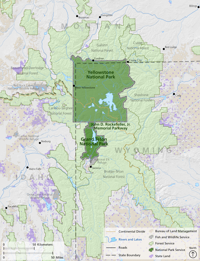 Keeping corridors within the ecosystem boundary is the foundation for connectivity with Island Park as a prime target in the GYE. NGOs and scientists are using the US 20 Corridor and Elk migration to advance connectivity at Targhee Pass. It has nothing to do with saving Elk, the Elk are being used for emotional manipulation and a distraction. Several targeted areas for redesign have now been narrowed down to just the Targhee Pass, only because it is the closest site for connectivity. With the Strategic Wildlife Action Plan (SWAP) identification of Species of Greatest Conservation Need (SGCN) and priority habitat conservation, along with other corridors, the plan has been established for sequential, consecutive, and progressive steps towards connectivity in the GYE, giving wildlife "room to roam". Island Park has a yellow star for high connectivity, this connectivity plan has been in the works for several years, and that is why she is being targeted.  Scientists and NGOs believe connectivity is needed for species population persistence, ensuring that one or many species can move freely throughout the landscape. Because they also believe humans cause connectivity "fragmentation" with land development, a highly aggressive effort is underway to convince land owners to place their land into conservation easements (CE), restrict or ban road use, restrict development and growth boundaries, buy land, and take advantage of road corridors for halting fragmentation. To these groups, connectivity means highly restricted human use to none at all. Corridors and connectivity are the means to control land use. Once land is in their possession, regardless of being a CE, protected or restricted area, or any other designation, control of that land will be dictated by the government, NGOs, and land trust groups. If your county elected officials allow it, these groups will try and convince them to change land use planning in comprehensive plans, forcing you to comply with conservation measures on your property, reduce land use, and dictate or halt how you use your land. The Wildlife Conservation Society (WCS) has already "provided site-specific science in this region to aid Fremont County, Idaho to prepare a comprehensive growth and subdivision plan that considers the importance of protecting biodiversity and wildlife migration corridors." The Northwest Property Owners Alliance (NWPOA) in northern Idaho has already been through it and can tell you what will happen if your county acquiesces. They experienced the same dynamics being used by the US 20 Corridor study team including failure to notify, misinformation, and domination by special interest groups. Their article on environmentalism really captures what Island Park is experiencing. In 2015, after two years of steering committee meetings (including UN NGOs and Canada), the Greater Northern Landscape Cooperative (GNLCC) released a preliminary "Connectivity Pilot Project" report and "...selected connectivity as a priority shared landscape objective...". The second of four objectives was to, "Conserve a permeable landscape with connectivity across aquatic and terrestrial ecosystems, including species movement, genetic connectivity, migration, dispersal, life history, and biophysical processes." The corridors discussed in part three, plus the others listed here will all be used to justify placing Island Park into a massive, large scale, conservation area and eventual integration into the GYE as a protected area, under complete conservation status, with controlled land use. This agenda has been in the works for years, using Elk and the US 20 corridor is just the first step. Their "data basin" is used to "inventory connectivity data"..."identify important areas for action"..."identify potential connectivity opportunities"...with the data also capturing..."'human footprint’ layers"..."land use stressors that may be expected to impact connectivity"..."as well as map layers representing jurisdictional boundaries." Island Park is specifically targeted in this report. Using the High Divide (HD) as their "connection", the short term objective included mitigating US 20 and Hwy 87 corridors and habitat augmentation at highway crossings. Long term objectives included annexing Henry's Fork and Island Park from the Great Basin Landscape Conservation Cooperative (GBLCC) to GNLCC; supporting collaborative work of state and federal agencies, and NGOs to conserve private lands and connect public lands; focusing on landscape water conservation; implementing highway mitigation for key linkages; and creating disincentives for wildlife urban interface (WUI-zone of transition between unoccupied land and human development). Participants in this report included Gary Tabor, Michael Whitfield, Gregg Servheen, and Renee Seidler, the new ITD road ecologist expert for the US 20 Corridor plan. Ms. Seidler has stated her belief in connectivity, her other work is on connectivity, the cooperative agreement between the ITD and IDFG states the job responsibilities included developing programmatic and site specific information and criteria on wildlife connectivity, and her job description states the same. Conveniently, IDFG Wildlife Coordinator, Gregg Servheen, is on the GNLCC Steering Committee mentioned above, and signed the contract between IDFG and ITD for the position Ms. Seidler eventually took through the Wildlife Management Institute (WMI). Mr. Servheen also works on helping you turn your land over for conservation easements (CE) through the Private Landowner Network, or find conservation resources. He worked with the Western Governor's Association (WGA) to build data bases on biological information for preserving wildlife corridors and habitats, and the goal to "complete a connectivity/linkage plan" along the High Divide. While all of this gives the appearance of impropriety, it is nothing more than a self-created, conglomerate of government agencies and NGOs, operating under no legal authority, working without public involvement on plans to address issues they created, disguising it as their concern about wildlife vehicle collisions (WVC), and which will eventually be used as an excuse for wildlife connectivity. WVC are nothing more than a distraction to keep you from learning about the connectivity agenda. A copy of the contract can be downloaded here.
In fact, the ITD and IDFG were so confident the US 20 Corridor project was in the bag, they hired Ms. Seidler by April 17th to move on to the connectivity phase. This was at least 10 days prior to the cancelled April 27th meeting that was supposed to include Island Park residents and their input. 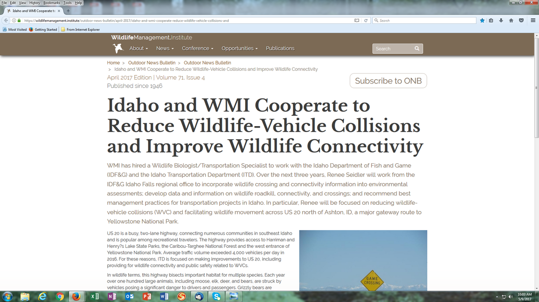 Ms. Seidler is well prepared for this job having previously conducted a study with IDFG in 2014 called: US 20, Island Park Wildlife Collision Study, An examination of Road Ecology in the Island Park Caldera: Elk and Moose Migration Across US Highway 20. The summary states, "Conservation and mitigation efforts for Elk and Moose...will likely have significant positive impacts on habitat connectivity...". A copy of this report can be downloaded here.
The GNLCC held a major workshop in 2015, Conservation of Continental Connectivity through Community Based Collaboration. Presenting at this workshop, the High Divide celebrated their increase in CE from 194,483 acres to 1.2 million in 9 years, and their work in connecting large core protected areas and wildlife connectivity. Their goal is Ecological linkage between protected core areas to conserve wide-‐ranging wildlife in response to climate change, not WVC. To them, "Working Across Boundaries" includes "Local expertise—stakeholder input". This has rarely been sought from Island Park, but rather from an assembly of scientists, government officials, and NGOs, few who even have one connection to Island Park. The goal is complete "protected" connectivity in large landscape areas where Island Park sits. GNLCC held a Resource Managers Connectivity workshop in April, 2015, with Ms. Seidler as a participant and Gary Tabor and Michael Whitfield as speakers. Mr. Whitfield was also on the program committee for the 2014 National Workshop on Large Landscape Conservation held in Washington, D.C.. Federal government agencies and NGOs comprised 76% of the participants, with only 1% landowners participating. As the founder of the Center for Large Landscape Conservation (CLLC), Gary Tabor has created both a Connectivity Conservation Hub in partnership with the GNLCC, located in Jackson, and a Ecological Connectivity Project with all the data and maps needed to conserve "a permable (sic) landscape with connectivity across its geography". According to Mr. Tabor, "A corridor is a distinct component of the landscape that provides connectivity. Wildlife corridors specifically facilitate the movement of animals, while other types of corridors may support connectivity for plants or ecological processes." The Ecological Connectivity Project brings "managers" together who focus on connectivity. "The goal of the project is to conserve a permeable landscape with connectivity across aquatic and terrestrial ecosystems, including species movement, genetic connectivity, migration, dispersal, life history, and biophysical processes." Michael Whitfield from the High Divide is also involved. This project does not include any Island Park residents, only government officials, NGOs, and initiative leaders. The justification for this project are primarily based on executive orders, policy resolutions, white papers, secretarial orders, and regulatory decisions that are not found in Idaho or federal law. However, GNLCC funding for 2017 is directed towards supporting this project for water, species, terrestrial and migration connectivity in large landscapes, your tax dollar.  Hidden on a US Geological Survey website is the 2015 proposal, "Landscape Conservation Design in the High Divide" with Mr. Whitfield as the Project Coordinator, and who is also the executive director of the Heart of the Rockies (HOR) initiative. Multiple NGOs, land trusts, and federal and state agencies are involved. The project summary "...seeks support to identify and evaluate future landscape configurations...emphasizing wildlife connectivity between large protected core areas..." such as Yellowstone. The need for "Landscape Conservation Design" was cited as one of the elements of the USFWS Strategic Habitat Conservation Plan. "A conservation design (cluster development) is a type of “Planned Unit Development” in which the underlying zoning and subdivision ordinances are modified to allow buildings (usually residences) to be grouped together on part of the site while permanently protecting the remainder of the site from development." This project supports the GNLCC Strategic Conservation Framework, one goal being to "Conserve a permeable landscape with connectivity across aquatic and terrestrial ecosystems...". All of the data collection will be used to redesign Island Park into some artificial utopian paradise, rather than let her exist as she has for centuries, or be developed through local representation. And with all due respect sir, do not lump residents into a "Human Modification Index. Workshops on this project were supposedly held in Nov 15' through Fed 16', conveniently when most residents were not available. This is how subversive these groups are. A copy of the proposal can be downloaded here.
These individuals and groups have been working with each other, making decisions about Island Park and the residents, behind their backs. Do those who live in Island Park want their covert plans?
The following initiatives and organizations are actively involved in the connectivity agenda: Heart of the Rockies (HOR); Yellowstone to Yukon (Y2Y), High Divide (HD), Crown of the Continent (COC), Greater Yellowstone Coalition (GYC), and Future West (FW). "Although America's national parks include some of the wildest places on Earth, no park in the U.S....is large enough to support the full range of native biological diversity over the long-term. In order to accommodate wide-ranging animals...our parks must be connected to other protected areas via wildlife corridors and their boundaries should be expanded wherever possible." (Rewilding Our National Parks) A brief word why so many "experts" are making the decisions. These scientists are actually technocrats, experts in science who have a lot of power in, or influence with the government and are an adherent of technocracy. Technocracy is the power shift from elected representatives and bureaucrats to technocrats (engineers, managers, scientists); management of society by technical experts; or a society that is controlled by scientists, engineers, and other experts. Is this not where we are at? Patrick Wood has a series of excellent videos on his website, Technocracy News and Trends, that provide valuable insight into how our government has transitioned over to these "experts" and away from the people. It is the responsibility of elected officials to listen to those who elected them, not technocrats or special interest groups, or those who are not Fremont county residents. Have we abdicated our inherent power and responsibility of self-governance to others? Or has it been stolen from us? No efforts have been taken to disclose or involve Island Park residents in these plans, no alternatives to overpasses and fencing have been discussed, no input has been sought from anyone except the UN NGOs, cooperatives, technocrats, and government agencies, and No discussion has ever taken place on their plans for connectivity. Studies were conducted for the US 20 Corridor plan without required prior notification to Island Park residents. And why should they bother, the protection of Elk is not the issue, it is a distraction from what they are really planning. All evidence points to the agenda for connectivity, on websites, in reports, participants own statements, and in studies. The ITD, their study team, NGOs, and initiatives have not been transparent with Island Park residents, misrepresented what they are actually doing, and have violated every drop of what is ethical. Shame on all of them. It is important to remember, there is no federal legislation for this agenda. What law allows arbitrary erasure of jurisdictional boundaries? This is a concerted effort by individuals and groups with an ideology, who have successfully engaged the government with the same ideology, and are proceeding forward without any laws. Island Park has a population of 286 as of 2016. That swells to several thousand during the summer when residents come to their summer homes. The number of individuals pursuing this connectivity and conservation agenda are in the thousands, with millions of dollars being funneled into it. Island Park residents, who own homes and pay taxes, are the guardians of Island Park, and who elect city and country officials to represent them. Officials are obligated to listen to their voice, not special interest groups from other states or counties. The technocrats and elite who believe they know better, and who hide their agenda, are usurping those rights. Is this what Fremont County citizens want? The Declaration of Independence states governments derive "...their just powers from the consent of the governed." The Idaho Constitution, Article I, Section 2 states, "All political power is inherent in the people." It is time to recapture the self governance our Founding Fathers created for us. No individual wants Elk harmed and WVC must certainly be addressed. However, tearing up and environmentally engineering the land for ulterior motives is not the solution, there are other alternatives beyond what the technocrats say won't work that require consideration. Island Park residents should be the lead in discussing these alternatives, how they want to protect her and the Elk, and the ones who hold the right to make those decisions. These technocrats and NGOs have zero connection to Island Park, spending their time reducing it to nothing more than a mathematical formula, and assigning point values for the purpose of artificially engineering it into something that it isn't. There is no Island Park asset that has more or less value than another and in spite of what they say or believe, this land is not "fragmented" by us, it is fully connected in every way. They are welcome to visit and walk on the path they designated, but respectfully, do not come to Island Park for environmental engineering, passing it off as a transportation project for saving wildlife when your true goal is connectivity and "conservation design". As her Guardians, Island Park is ours to protect, not yours to alter. Part 5 will reveal where all of this originated. |
Concerned Idahoans:This website is non-partisan and is solely dedicated to removing the harmful controls placed on our state and nation through associated programs of Agenda 21, Agenda 2030, and the Great Reset. We invite all Idahoans to join us in this fight for freedom! Categories
All
Archives
March 2024
|
||||||
 RSS Feed

